
Municipality Kula
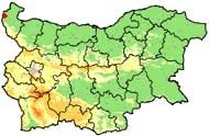
 The municipality of Koula is situated in northwestern Bulgaria (province Vidin) at the westernmost edge of the Danube Plain, 32 km from the District Center Vidin. Its territory covers two morphological structural units - the hilly Danube Plain and the foothills of the Balkan Range (the Fore-Balkan). The relief is hilly and flat, cut across by the river valleys of the Topolovets and Chichilska rivers. The average altitude is 295 m above sea level.
 To the west Koula municipality borders the Republic of Serbia along a 12 km borderline. The hilly Balkan range extends to the south and southeast at an altitude of 300 - 500 m.
The climate is moderate continental with cold winters and hot summers. The soils are humus (black earth) in the plain and brown soils in the higher areas, suitable for the development of agriculture.
Landmarks:
- The Holy Trinity Monastery (12 century) is situated near the village of Rakovitsa and functions as a tourist facility (at a distance of 21 km from town of Kula).
- There is a tourist route leads from the monastery to the Babin Nos and Chernoglav peaks.
- The Vrashka Chuka protected natural sight is located on the territory of the municipality.
- The ruins of the Kastra Martis (2 c.) - Roman fortress dating back to late antiquity and giving the name of the town can be found in the center of the Municipality.
Quick facts about Municipality Kula
In Bulgarian (Native transliteraion): Община КулаOther transliteration(s): Koula
Region: North-Western planing region of Bulgaria
District: Vidin district
Municipality: Kula municipality
Latitude: 43.8880005
Longtitude: 22.5209999
Altitude: 4
Area Size: 280km2
Population: 5827 people (2005)
Photos Municipality Kula (27) »


News Municipality Kula (2) »
2010-10-13 Castra Martis fortress in town of Kula (Culture)
2008-08-08 Bulgaria Police Seizes 9 Kilos of Cannabis from 81-Year-Old Grower (Accidents)
Map of Municipality Kula »
Location
РЕМОНТИ Видин
