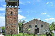
Village Zvezdets

Photo: bgglobe.net
 The village of Zvezdets is located in Strandja Mountain (South-East Bulgaria). It is included in Municipality Malko Turnovo (Bourgas District). The megalith monuments and Thracian tombstones on the territory of the village give evidence for its important role as a center in the antiquity.
Its old name comes from the Turkish name of the Gyoktepe hill (Sky peak). In the years of Turkish yoke Zvezdetz was located on the main road from Fakia to the town of Iniada. That was the reason for the growth of the village. When the Turks burned down the village, the survivors decided to move west, under "Beliat kamak" (The White stone) – a natural defense from the winds. By that time the place they chose was overgrown with a dense natural forest. The houses were built of wood from the same forest, whittled on the very place.
Quick facts about Village Zvezdets
In Bulgarian (Native transliteraion): Село ЗвездецOther transliteration(s): Zvezdec, Zvezdetz
Region: South-Eastern planing region of Bulgaria
District: Bourgas district
Municipality: Malko Turnovo municipality
Latitude: 42.1166649
Longtitude: 27.4166660
Altitude: from 300 to 499
Distance by air to the capital city Sofia: 342.421km
Area Size: 91.489km2
Population: 525 people (31.12.2013)
Postal Code: 8360
Phone Code: 05959
Photos Village Zvezdets (3) »
External links Village Zvezdets
Zvezdets (Zvezdets)
Zvezdets (Zvezdets)


