
Municipality Kameno
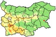
 The Kameno municipality is situated on an area of 354.7 sq. km in the fertile Bourgas Lowland. Its administrative centre - the town of Kameno - is 20 km eastwards of the district centre Bourgas.
 The territory is situated in the plain part of Southeastern Bulgaria, along the lower stream of the Aitoska River.
The municipality consists of 13 settlements: the municipal centre - the town of Kameno - and the villages of Krastina, Vinarsko, Vratitsa, Troyanovo, Zhelyazovo, Rousokastro, Livada, Trastikovo, Konstantinovo, Polski Izvor, Cherni Vrah and Svoboda.
The area of the urbanized territories is 16542 decares.
The number of the dwellings is 6670. A large part of the dwellings in the villages are used seasonally as villas.
Quick facts about Municipality Kameno
In Bulgarian (Native transliteraion): Община КаменоRegion: South-Eastern planing region of Bulgaria
District: Bourgas district
Municipality: Kameno municipality
Latitude: 42.5830002
Longtitude: 27.2999992
Altitude: 1
Area Size: 354.7km2
Population: 12896 people (2005)
Photos Municipality Kameno (19) »


News Municipality Kameno (1) »
2008-11-04 Cyrillic scripture from X-th century was found near village of Rusokastro (Culture)
External links Municipality Kameno
www.kameno.com (Kameno)
bulgaria.domino.bg (Kameno)
Map of Municipality Kameno »
Location
РЕМОНТИ Боургас
