Select language bg en
Image From Bulgaria

Municipality Saedinenie


Photo: mirela.bg
The Saedinenie municipality is situated in the Plovdiv district (South - Central Bulgaria) in Thracian Valley in the foot of Sredna Gora Mountain. The municipal center town of Saedinenie is immediately next to Trakia highway. The territory of the Municipality is traversed by the Plovdiv - Panagurishte railway line. The flat terrain, the availability of good network of canals and underground water are conducive to the growing of intensive crops.
On the teritoty of the municipality Suedinenie there are two centuries-old oak trees: a common oak tree (Sabev oak) of over 200 years of age, and a common oak tree in Tseretelevo village.

Quick facts about Municipality Saedinenie

In Bulgarian (Native transliteraion): Община Съединение
Other transliteration(s): Suedninenie
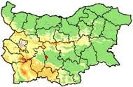
Region: South-Central planing region of Bulgaria
District: Plovdiv district
Municipality: Saedinenie municipality
Latitude: 42.2669983
Longtitude: 24.5499992
Altitude: 3
Population: 10975 people (2005)

Photos Municipality Saedinenie (10) »


Lyuben

Lyuben

Golyam chardak

Golyam chardak

Malak chardak

Golyam chardak

Malak chardak

Saedinenie

Malak chardak

Saedinenie

News Municipality Saedinenie (1) »

2008-04-16 Man Found Dead in Ditch near Plovdiv (Accidents)

Map of Municipality Saedinenie »

Location
Saedinenie
РЕМОНТИ Пловдив
Ремонти на...
Фирми и обяви за ремонт сгради, апартаменти, автомобили, техника и електроника в Пловдив


DONATION
PayPal
Vidin Montana Vratsa Pleven Rousse Silistra Dobrich Varna Veliko Turnovo Razgrad Turgovishte Shoumen Bourgas Yambol Sliven Haskovo Stara Zagora Gabrovo Plovdiv Kardjali Smolyan Pazardjik Blagoevgrad Kyustendil Lovech Sofia City Sofia County Pernik