
Village Glavan
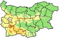
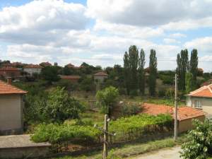 The village of Glavan (Stara Zagora District) is located in the foods of the Sakar mountain (South-Eastern Bulgaria) and is included in Municipality Galabovo. It is lies at 32 km away from the municipal town of Gulubovo, 70 km from the district center Stara Zagora, 43 km from the town of Svilengrad, 32 km from the town of Harmanly, 30km from town of Topolovgrad and 39 km from the town of Radnevo.
Glavan has good connection with the neighbouring villages and towns because the main roads Harmanli - Topolvgrad, Harmanli - Galabovo and the crossroad "Golyamata zvezda" (The Big star) situated near it.
Near the village were found remains of ancient Thracian hamlet named Glasin (later Glasin goes to Glavin from where is origin of the name Glavan).
Quick facts about Village Glavan
In Bulgarian (Native transliteraion): Село ГлаванRegion: South-Eastern planing region of Bulgaria
District: Stara Zagora district
Municipality: Galabovo municipality
Latitude: 42.0670013
Longtitude: 26.1000004
Altitude: from 300 to 499
Distance by air to the capital city Sofia: 238.626km
Area Size: 61.12km2
Population: 920 people (31.12.2013)
Postal Code: 6295
Phone Code: 04155
Photos Village Glavan (9) »


Map of Village Glavan »
Location
РЕМОНТИ Стара Загора
