
Municipality Bratya Daskalovi
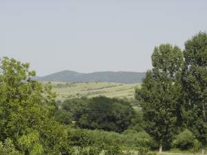 Bratia Daskalovi Municipality is located South-Eastern Bulgaria in the Upper Thracian Valley and encompasses the western parts of the Chirpan Hills. The small population centers with less than 500 residents predominate in the municipality. The smallest is the village of Slavianin and the most populated are the villages of Cherna Gora, Orizovo, Granit and municipal center village of Bratia Daskalovi. The municipality has a good transport and geographic position.
 29% of the total territory is forest area, generally localized in the southern hills of Sarnena Sredna Gora Mountain. The municipal lands are about 32,000,000 sq.m. Apart from these, the municipality also manages approximately 20,000,000 sq. m of farming land.
Quick facts about Municipality Bratya Daskalovi
In Bulgarian (Native transliteraion): Община Братя ДаскаловиOther transliteration(s): Bratia Daskalovi
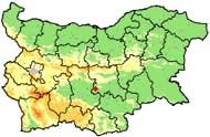
Region: South-Eastern planing region of Bulgaria
District: Stara Zagora district
Municipality: Bratya Daskalovi municipality
Latitude: 42.2999992
Longtitude: 25.2169991
Altitude: 3
Population: 8497 people (2005)
Photos Municipality Bratya Daskalovi (12) »


News Municipality Bratya Daskalovi (2) »
2011-08-03 Italians started construction works on a section of the Maritsa motorway between Orizovo and Dimitrovgrad (Transport)
2010-10-18 Halka Bunar Thracian Centre near village of Gorno Belevo (Culture)
External links Municipality Bratya Daskalovi
bulgaria.domino.bg (Bratya Daskalovi)
Map of Municipality Bratya Daskalovi »
Location
РЕМОНТИ Стара Загора
