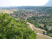
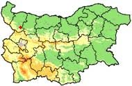
Village Botunya

Photo: Cvetan Iliev - selo.bg
Sightseeing:
- Many holes and caves in karst terrain in the vicinity. Some of the caves as "Vodnata dupka " ("The Water Hole") were inhabited during the Neolithic.
- The ruins of an ancient fortress are located on the rock terrace Gradishte and were declared cultural monument in 1969.
- There are two centuries-old trees at 500 m west of the village in the area of "Kamaka" ("The Stone").
- The Locality Kirik, which is located about 500 meters west of the village, is a place with great views to the river of Botunia and nearby villages.
- There are 6 old trees and memorial plaque in place, which is located 1000 meters north of the village.
- In the village there is a Memorial of Died for the Liberation Bulgaria
Quick facts about Village Botunya
In Bulgarian (Native transliteraion): Село БотуняOther transliteration(s): Botunia
Region: North-Western planing region of Bulgaria
District: Vratsa district
Municipality: Krivodol municipality
Latitude: 43.2879982
Longtitude: 23.3610001
Altitude: from 200 to 299
Distance by air to the capital city Sofia: 67.365km
Area Size: 18.172km2
Population: 155 people (31.12.2013)
Postal Code: 3046
Phone Code: 09181


