
Municipality Anton
 The Anton Municipality is situated in the northeastern part of the Zlatitsa - Pirdop hollow (South-West Bulgaria, Sofia district). There is only one village on municipality - village of Anton. The land of the village reaches the southern slopes of the Teteven ridge of the Balkan Range, which is a part of the largest National Park - the Central Balkan Range. The average height above sea level is 847 m. An interesting component of the natural-geographic characteristics of Anton village is the water. Seven rivers flow through the territory of the Municipality, and there are a total of 14 rivers on its land. Anton Municipality is crossed by the main road I-6 Sofia - Bourgas and the sub-Balkan railway line. The neighboring municipalities are: Pirdop, Teteven, Zlatitsa and Koprivshtitsa.
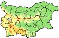
 The beautiful nature and the pure mountainous air make region of Anton an attractive place for tourism. Near the village are located the mountain huts Paskal, Planinski Izvori, Momina Polyana, and Sveshti Plaz. The Dalbochitsa River, which mouths into Doushantsi Dam Lake, is a preferred fishing place.
Quick facts about Municipality Anton
In Bulgarian (Native transliteraion): Община АнтонRegion: South-Western planing region of Bulgaria
District: Sofia district
Municipality: Anton municipality
Latitude: 42.7500000
Longtitude: 24.2830009
Altitude: 7
Area Size: 76km2
Population: 1685 people (2005)
Photos Municipality Anton (6) »


Map of Municipality Anton »
Location
РЕМОНТИ София
