
Municipality Brusartsi
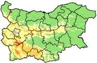
 Broussartsi Municipality is located in the northwestern part of Bulgaria (Monatan district) in the northern part of Danube hilly plane. It is situated at the side of the river "Nechinska bara" (right tributary of river Lom). Road and railway connections link the Municipality to town of Lom (25 km), where the nearest operational Danube port is situated. The District Center Montana is 37 km away, the ferryboat complex in Vidin town is 52 km away.
 The plane relief, the natural soil fertility and the capacity for mechanized land cultivation are prerequisites for development of plant-growing, mainly cereals, grain fodder and technical crops, vineyards and orchards, and also cultivated growing of forest fruits.
The Municipality Brusartsi consists of 1 town and 9 villages.
Quick facts about Municipality Brusartsi
In Bulgarian (Native transliteraion): Община БрусарциOther transliteration(s): Brusarci, Bousartsi, Broussartsi, Brousarci, Brusartzi
Region: North-Western planing region of Bulgaria
District: Montana district
Municipality: Brusartsi municipality
Latitude: 43.6666718
Longtitude: 23.0666695
Altitude: 2
Area Size: 194.5km2
Population: 6103 people (2005)
Photos Municipality Brusartsi (6) »


External links Municipality Brusartsi
www.brusartsi.org (Brusartsi)
Map of Municipality Brusartsi »
Location
РЕМОНТИ Монтана
