
Municipality Dospat
 Municipality of Dospat is situated in the southwestern part of Bulgaria and covers a territory of 2,551,750 decares. The municipality comprises an area of the so-called "Batashko-Dabrashki dyal" - a part from the Western Rodopi mountains. It shares a common border with the Republic of Greece to to the south, a common border with the municipality of Batak to the north, with the municipality of Satovtcha to the west and with the municipality of Borino to the east.
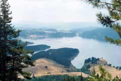
 The relief is mountainous. The forests occupy 70 % of the municipal territory and cover 178 hectares. The following kinds of trees can be found: white pine, spruce, birch, hornbeam, beech, winter oak, fir-tree, juniper, black pine. The larger rivers are Dospat and Karadja dere. There is a dam lake called "Dospat" which is 18 km long, 3 km wide, 40 m deep and has water capacity of 420 million m3. It is used for the production of electricity, fish-breeding, fishing and water tourism.
The prevailing climate is mountainous and influenced by the Mediterranean Sea.
The region of Dospat is ecologically clean. There are not regulated waste dunghills and the following reserves: "Omana", "Barak" and "Topchilii", the following representatives of the flora like: fern, corn-flower, bramble, red blueberry, thymus serpillorum, primrose and representatives of the fauna, typical for the Central European Region: boar, doe, deer, wolf, brown bear, wood-grouse capercalzie, etc.
Quick facts about Municipality Dospat
In Bulgarian (Native transliteraion): Община ДоспатRegion: South-Central planing region of Bulgaria
District: Smolyan district
Municipality: Dospat municipality
Latitude: 41.7000008
Longtitude: 24.1170006
Altitude: 8
Area Size: 255km2
Population: 10527 people (2005)
Photos Municipality Dospat (7) »


News Municipality Dospat (4) »
2010-03-18 Dospat-based plant pays off its workers by clothes (Other)
2008-02-15 Bulgarian Triumphed on the Ski Orientation World Cup Championship (Sport)
2008-02-08 Dospat Hosts World Cup Championship for Ski Orientation (Sport)
2007-07-03 The dam of Dospat (Travel)
External links Municipality Dospat
www.bulguide.com (Dospat)
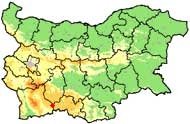
Map of Municipality Dospat »
Location
РЕМОНТИ Смолян
