
Municipality Varbitsa
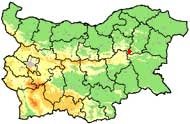
 The Varbitsa municipality is located in North-East Bulgaria in Shoumen District. The Municipality consists of 1 town (municiapl center Varbitsa) and 15 villages. The territory of the Municipality is crossed by main road 1-7 Silistra - Shoumen - Yambol, which ensures convenient connection between Southern and Northern Bulgaria through Varbitsa Pass.
 Varbitsa Municipality is situated in the Gerlovska hollow, in the foot of the Eastern Balkan Range and is an environmentally clean region. There are no large companies in the vicinity to pollute the environment. Tourist routes are spread all over the mountain. Tourists may find accommodation in a large and well maintained tourist hut located in the beginning of the Varbitsa mountain pass.
Quick facts about Municipality Varbitsa
In Bulgarian (Native transliteraion): Община ВърбицаOther transliteration(s): Vurbitsa, Varbica, Vurbica
Region: North-Eastern planing region of Bulgaria
District: Shoumen district
Municipality: Varbitsa municipality
Latitude: 43.0000000
Longtitude: 26.6333294
Altitude: 4
Area Size: 419.364km2
Population: 14638 people (2005)
Photos Municipality Varbitsa (21) »


News Municipality Varbitsa (1) »
2009-11-11 Varbitsa Pass closed for the entire winter season, available are Rish and Kotel passes (Transport)
External links Municipality Varbitsa
Oficial site of Byala Reka village (Byala reka)
Map of Municipality Varbitsa »
Location
РЕМОНТИ Шоумен
