
Municipality Tutrakan
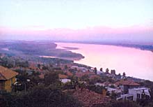 Toutrakan municipality is part of Silistra district. It covers an area of 440 sq. m located in the north-eastern part of the Danube plain. It includes the municipal centre town of Toutrakan and 15 villages: Antimovo, Belitsa, Brenitsa, Varnentsi, Dounavets, Nova Cherna, Pozharevo, Preslavtsi, Staro Selo, Syanovo, Turnovtsi, Tsar Samouil, Tsarev Dol and Shoumentsi.
According to the climatic division of Bulgaria the lowland of Toutrakan region belongs to the temperate continental climatic region.
Quick facts about Municipality Tutrakan
In Bulgarian (Native transliteraion): Община ТутраканOther transliteration(s): Toutrakan
Region: North-Central planing region of Bulgaria
District: Silistra district
Municipality: Tutrakan municipality
Latitude: 44.0499992
Longtitude: 26.6170006
Altitude: 2
Area Size: 440km2
Population: 20518 people (2005)
Sights & Landmarks Municipality Tutrakan (10) »
Shumentsi: St. George's Temple
Tutrakan: Memorial Complex Military Tomb Tutrakan
Tutrakan: Fortress Transmariska
Tutrakan: Archeological museum Tutrakan
Tutrakan: Church St. Nicola
Tutrakan: Sabri Hyuseyin (Softa Baba) Tyurbe
Photos Municipality Tutrakan (128) »


")


News Municipality Tutrakan (4) »
2012-10-05 Procedure for 35-year concession contract for the Tutrakan port terminal (Transport)
2009-08-13 The Fishermen`s village of Tutrakan (Society)
2008-08-18 Youngster Found Dead in Bulgarian Village (Accidents)
2008-05-26 Worker Crushed by Truck in Bulgaria`s Tutrakan (Accidents)
External links Municipality Tutrakan
www.tutrakan.bg (Tutrakan)
www.obs.tutrakan.org (Tutrakan)
bulgaria.domino.bg (Tutrakan)
www.tutrakan.bg (Tutrakan)
www.tutrakan.org (Tutrakan)
Тхе Fisherman hamlet (Tutrakan)
Map of Municipality Tutrakan »
Location

РЕМОНТИ Силистра
