
Village Lyutibrod
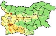
 The village of Lyutibrod is located in North-West Bulgaria. It is part of Mezdra Municipality, Vratsa District. Village is situated at the two shores of Iskar river. East there are a valley and agricultural land, at south – lawns and forests, at west - rocks and at north – vineyards, fruit gardens, forests and lawns.
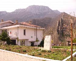
 Sightseeing: Liutibrod has many cultural monuments. Some years ago the native people were eager to declare the village for an Open Museum. Against Liuti brod are situated the famous erected rocks Ritlite – unique in whole Europe. In close proximity is the debris of the ancient Roman city Koriten. From the old city is preserved a church and basis of an ancient castle. There are also debris from the sewerage system of the village and a bath close to the river. 200 m from the village of Lutibrod is the area of "Rashov dol" – the place where the detachment of Hristo Botev (a Bulgarian revolutionary) led its final fight with the Ottoman army.
At 1 km from "Rashov dol" area is located the Cherepishki monastery – fortress of Bulgarian spirit throughout the centuries.
Quick facts about Village Lyutibrod
In Bulgarian (Native transliteraion): Село ЛютибродOther transliteration(s): Lutibrod, Lyuti brod, Liutibrod
Region: North-Western planing region of Bulgaria
District: Vratsa district
Municipality: Mezdra municipality
Latitude: 43.0999985
Longtitude: 23.6329994
Altitude: from 300 to 499
Distance by air to the capital city Sofia: 53.032km
Area Size: 25.458km2
Population: 330 people (31.12.2013)
Postal Code: 3159
Phone Code: 09109
Photos Village Lyutibrod (39) »


Map of Village Lyutibrod »
Location
РЕМОНТИ Враца
