
Municipality Beloslav
 Beloslav Municipality spreads over a territory of 91.3 square
miles and borders with the municipalities of Varna, Devnya and Avren. According to the physical geographic division
of the Bulgarian regions, Beloslav
falls within the Black Sea Coastal District. The district covers the
Beloslav and part of the Varna lakes, the canal uniting them,
as well as the adjacent lowlands. The southern part of the territory encompasses
the northern slope of the Avren plateau.
Beloslav Municipality spreads over a territory of 91.3 square
miles and borders with the municipalities of Varna, Devnya and Avren. According to the physical geographic division
of the Bulgarian regions, Beloslav
falls within the Black Sea Coastal District. The district covers the
Beloslav and part of the Varna lakes, the canal uniting them,
as well as the adjacent lowlands. The southern part of the territory encompasses
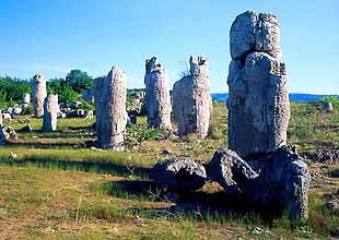
the northern slope of the Avren plateau.The largest part of the territory (about 81%) is occupied by the lowland and the lakes and only a small part (about 19%) – by the Avren plateau slopes, which provides favorable conditions for the development of local industry, transport and tourist infrastructure. The famous natural phenomenon of Pobiti kamani (Fossil Forest) is situated at the teritory of the municipality near the village of Strashimirovo.
The infrastructural, economic, environmental and social development of Beloslav Municipality is determined by its affiliation with the Varna-Provadia-Devnya transport and settlement agglomeration.
The geographical position of Beloslav benefits the development a transport and communication system servicing both national and international infrastructural destinations. The trans-European transport corridor No.8 crosses the municipality’s territory and ends in the overground appurtenances of the ferryboat terminal. According to the project decision the motorway trace passes through the town of Beloslav and the village of Strashimirovo in order to avoid the environmental pollution of the adjacent built-up areas.
Quick facts about Municipality Beloslav
In Bulgarian (Native transliteraion): Община БелославRegion: North-Eastern planing region of Bulgaria
District: Varna district
Municipality: Beloslav municipality
Latitude: 43.1829987
Longtitude: 27.7000008
Altitude: 1
Area Size: 91.3km2
Population: 11561 people (2005)
Sights & Landmarks Municipality Beloslav (4) »
Beloslav: Natural phenomenon Pobitite kamani
Razdelna: Petrich kale fortress
Strashimirovo: Memorial plate of Nikola Lefterov
Strashimirovo: "Nikolay the miracle worker" church
Photos Municipality Beloslav (23) »


News Municipality Beloslav (4) »
2011-06-20 Varna has new waste recycling plant in village of Ezerovo (Politics)
2009-06-24 Glass production factory in Beloslav is one of the most visited tourism sites in the region (Travel)
2009-02-02 Problems for Beloslav glass factory (Other)
2005-06-20 The Stone forest (Travel)
External links Municipality Beloslav
Beloslav from VisitToBulgaria.com (Beloslav)
Map of Municipality Beloslav »
Location

РЕМОНТИ Варна
