
Municipality Antonovo
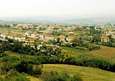 The Antonovo municipality is situated in Northeast Bulgaria, in the southwest part of the District of Targovishte. It borders the municipalities of Popovo, Targovishte and Omourtag (the District of Targovishte) to the north, northeast and east; the Kotel municipality (the District of Sliven) to the southeast; the municipalities of Elena, Zlataritsa and Strazhitsa (the District of Veliko Tarnovo) to the southwest and northwest. It occupies an area of 472 km2.
The municipality`s whole territory is situated in the Fore Balkan. It encompasses the low-mountain area Slannik, the Antonovo Elevations and the valleys of the rivers Golyama Reka and Stara Reka.
The unpolluted nature, the soft winters and the pure river water in the Antonovo municipality are a good potential for the development of country, ecological and hunting tourism. The Roman Bridge and the old fortress add to the attractiveness of the region of the village of Stevrek. There are ideas about the foundation of a game reserve in the southwestern part of the municipality under the administration of the Bulgarian Hunting and Fishing Union.
Quick facts about Municipality Antonovo
In Bulgarian (Native transliteraion): Община АнтоновоRegion: North-Eastern planing region of Bulgaria
District: Turgovishte district
Municipality: Antonovo municipality
Latitude: 43.1500015
Longtitude: 26.1669998
Area Size: 472km2
Population: 7974 people (2005)
Photos Municipality Antonovo (15) »


External links Municipality Antonovo
Map of Municipality Antonovo »

